CERN in detail
Authors/Creators
Description
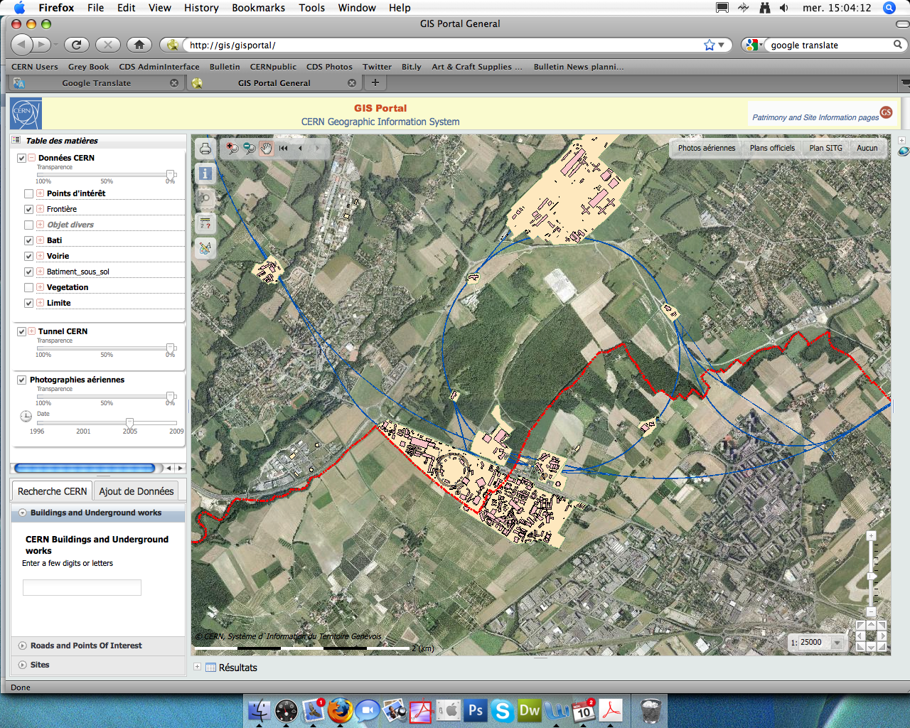
Before, you had to go on the TPG website to find a tram-route, use Google Maps to see an aerial photo of CERN, and look for CERN buildings on map.web.cern.ch. Now, that's ancient history, with a new Geographical Information System (GIS) Portal set up by the Design Office and Patrimony Service (GS/SEM/DOP). It's a one-stop-shop for all this information and much more.
Over the past few days, you might have noticed the new interface called MAPSearch that pops up when you make a building search using the Building and Roads field on the CERN homepage. This is a simplified version of the new GIS web Portal, a project on which the GS Department's Design Office and Patrimony Service has been working since January 2010. "In today's informatics age, we need to respond ever more quickly to increasing numbers of specific user requests," explains Project Leader Youri Robert.
This is more than just a new release of an old tool, it's a completely new-generation data management system. Previously, geographical data were stored on a system called STAR. This was not widely used as it was unreliable, slow and could not be accessed from Macintosh computers. "The new system is more powerful and user-friendly and has an array of attractive new features. The system was rolled out to the GS Department a few weeks ago and the feedback has been very positive," Youri explains. "The many users of our service will now be able to obtain paper copies of maps and drawings without having to come all the way to our offices. They will be able to download the information straight to their desktop." Another objective of the GIS portal is to bring as much information as possible into one repository in order to create a dynamic, attractive and user-friendly database, where people are happy to share data. With this system, maps and drawings can be updated in real time.
When you open the new tool, the aerial view of the site is displayed by default, but users can alter the settings to display CERN's official map, including road-names. And the map isn't just limited to the CERN site but also gives the entire Canton of Geneva, thanks to a hook-up with Geneva's own geographical database (Système d’information Géographique du Territoire de Genève). More specific information, like the location of tunnels or electrical networks and topographical data, can be accessed from inside the CERN site via the GIS Portal. The Portal offers a variety of useful features, ranging from simple building searches to the measurement of distances and the direct input of users' own data. It's also possible to consult the specific characteristics of all buildings and objects on the site. There are features to suit everyone's needs and interests.
CERN is a vast organisation with 15,000 rooms in 600 buildings with 1,500 separate floors. For some weeks now, Youri Robert has been working on a new tool based on the same technology, where drawings of all CERN rooms, by floor, will be available on line. The tool will give information on each individual unit (occupant, surface area, responsible Department, etc.). "Every floor will be represented on a separate drawing showing each individual room. Having this information available in the form of a drawing on-line will be of great benefit to many users, especially space managers who are constantly having to update their drawings as soon as a partition goes up or comes down or someone changes office," Youri concludes.
Try out these new tools today. The video demo here will guide you through the various basic features.
Other (French)
Avant, vous cherchiez le trajet de votre tram sur le site des TPG, les photos aériennes du CERN sur Google maps et l’emplacement des bâtiments sur le site map.web.cern.ch. Maintenant, avec la mise en place d'un nouveau système d’information géographique (GIS Portal) par le Service de l'information du site et du patrimoine (GS SEM DOP), c'est de l'histoire ancienne. Toutes ces informations sont à présent regroupées dans un même outil.
Vous avez sûrement remarqué la nouvelle interface de Building and Roads, aujourd'hui appelée MAPSearch. En effet, depuis quelques jours, lorsque vous cherchez la localisation d'un bâtiment, une nouvelle interface apparaît. Il s’agit d’une version simplifiée du portail web SIG, un projet auquel le Service de l’information du site et du patrimoine travaille depuis janvier 2010. « Aujourd'hui, à l'ère de l'informatique, il est important de pouvoir répondre rapidement aux demandes de plus en plus croissantes et spécifiques des utilisateurs », explique Youri Robert, chef du service en charge du projet.
Cet outil n'est pas seulement une évolution de l'ancien système, mais bel et bien un nouveau système de gestion des données. Auparavant, les données géographiques étaient stockées dans un système qui s'appelait STAR. Peu de gens l'utilisaient car il était peu fiable, lent et inaccessible depuis un MAC. "Le nouveau système est beaucoup plus performant, convivial et ses nombreuses fonctionalités le rendent plus attractif. Cela fait maintenant quelques semaines que le département GS l'utilise et les retours sont très positifs", souligne Youri. De nombreux utilisateurs n’auront plus à se déplacer jusque dans nos locaux pour obtenir un plan papier. Ils auront un accès direct à l’information depuis leur ordinateur. L'objectif du portail web SIG est aussi de centraliser un maximum d’informations au même endroit afin de créer une base de données performante, attractive, simple à utiliser et de donner envie aux gens de partager leurs données. Avec ce système, les plans seront enrichis au fur et à mesure.
Lorsque vous ouvrez ce nouvel outil, la vue aérienne s'affiche par défaut, mais vous pouvez également afficher le plan officiel, ce qui vous permettra de voir le nom des rues. Le plan s'étend non seulement à l'ensemble du site du CERN, mais également au Canton de Genève grâce à la collaboration avec le SITG (Système d’information géographique du territoire de Genève). Si vous recherchez des informations encore plus spécifiques, telles que l'emplacement des tunnels, des réseaux électriques ou encore les données topographiques, vous pouvez vous rendre sur le GIS Portal accessible depuis l’intérieur du CERN. Vous y trouverez de nombreuses fonctionnalités plus utiles les unes que les autres. Cela va de la simple recherche de bâtiments à la mesure de distances en passant par l'ajout de vos propres données. Il est également possible de consulter l'ensemble des bâtiments et des objets du site afin d'en connaître leurs caractéristiques. Chaque utilisateur pourra alors trouver une fonctionnalité qui l'intéresse.
Le CERN est une gigantesque organisation qui comprend plus de 15 000 locaux, 600 bâtiments et 1500 étages. Depuis quelques semaines, Youri travaille sur l'élaboration d'un nouvel outil basé sur la même technologie, où tous les plans des locaux du CERN classés par étage seront disponibles en ligne. Cet outil donnera des informations sur le local (occupant, superficie, département gestionnaire, etc). « Chaque étage sera représenté sur un plan où l'on pourra visualiser les différentes pièces. La représentation sous forme de plan disponible sur le web sera un outil fortement apprécié d’un grand nombre d’utilisateurs, notamment des gestionnaires d'espaces qui doivent constamment refaire leurs plans lorsqu'une cloison est crée, supprimée ou qu’une personne change de bureau », conclut Youri.
N'hésitez pas à tester les multiples fonctionnalités de ces outils. Afin de faciliter vos recherches, une vidéo vous guidera dans vos premiers pas ici.
Files
GISPortal(1)_image.png
_image.png?download=1)
_image.png?download=1)
_image.png?download=1)
Additional details
Identifiers
- CDS
- 1306545
- CDS Report Number
- BUL-NA-2010-318
Related works
- Is published in
- Periodical issue: 4jhb3-ry088 (CDS)
- Periodical issue: 4whs5-mjc39 (CDS)