CERN helps with the mapping of natural disasters
Authors/Creators
Description
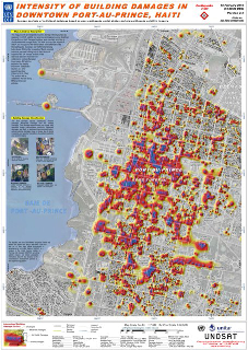
The headquarters of UNOSAT, the Operational Satellite Applications Programme of the United Nations Institute for Training and Research, are in an unassuming office, not far from Restaurant 2. There, UN experts are on hand twenty-four hours a day, seven days a week, waiting for an emergency message from anywhere on the globe and ready to respond. It was there that experts were called upon to respond to the recent earthquakes in Haiti and Chile, using CERN computing resources to develop some of the first response maps.
In the weeks following, UNOSAT members were on shift continually, day and night, working nonstop to develop reports of the damage. UNOSAT also sent two staff members on the ground to verify and improve upon their reports. “Especially in the early days of a disaster like Haiti or Chile, you hear ‘oh, the whole city is flattened,’ but normally, that’s not the case... Using satellite technology allows us to have more objective information available,” explains UNOSAT’s Humanitarian Task Manager, Einar Bjorgo.
UNOSAT downloads data from scientific and commercial satellites to CERN servers. These satellites have a resolution of down to 40 cm, allowing images with tremendous detail. In the case of Haiti, satellite technology was complemented by aerial photography at 15 cm resolution, and frequently radar data are also used. The collected data are then analyzed by UNOSAT experts.
Rather than relying exclusively on automated computer software, UNOSAT analysts conduct painstaking analyses themselves and have developed innovative techniques to answer questions often difficult to answer using satellite imagery. Their analytical techniques have earned the attention and support of several large companies, including ESRI, Google, and Microsoft, with which UNOSAT works, as well as government agencies, including those from the United States and Switzerland.
UNOSAT reports are used for multiple applications. Emergencies and natural disasters, such as Haiti and the more recent earthquake in Chile, require rapid mapping. Typically, UNOSAT is called in to assist with an average of forty humanitarian emergencies a year, easily three emergencies each month, and remains involved for five or six weeks, long after media attention has died down.
UNOSAT is also called on by the UN to assist in human security and human rights issues. UNOSAT has mapped out conflict zones in Gaza and Georgia, and reported on Somalian pirate activity. Working with satellite archives, UNOSAT is also assisting efforts in Indonesia to re-grow mangrove forests destroyed by the shrimp farm industry, which are vital to protecting the country from major tsunamis such as the one in 2004. Developing countries request UNOSAT’s assistance in geospatial training and mapping to lay out cities, farms, and transportation. There are also pure research projects at UNOSAT, such as developing GIS technologies on the computing grid or studying different geospatial correlates to social and humanitarian issues.
In all of their projects, UNOSAT relies on CERN computing support and IT. “CERN is the secret of our success,” explains Francesco Pisano, Manager of UNOSAT. “If we weren’t here we would have to equip ourselves with such an amount of IT that it would make this venture very difficult to fund from the UN. Compared to other set-ups around the world, we have virtually unlimited computing capacity.”
In turn, what CERN gains in the relationship with UNOSAT is the pride of participating in a project that provides global and humanitarian applications for the Laboratory’s computing infrastructures.
Other (French)
UNOSAT, le Programme des applications satellitaires opérationnelles de l'Institut des Nations Unies pour la formation et la recherche (UNITAR), est hébergé au CERN, non loin du Restaurant n°2, dans un modeste bureau. Des experts des Nations Unies s’y tiennent prêts à recevoir 24 heures sur 24, 7 jours sur 7, un message d’urgence envoyé d’un point quelconque de la planète, et à y répondre immédiatement. C’est là que des experts ont été contactés suite aux récents tremblements de terre d’Haïti et du Chili afin qu’ils établissent, à l'aide des ressources informatiques du CERN, les premières cartes en vue des secours.
Au cours des semaines suivantes, les membres d’UNOSAT ont travaillé par roulement jour et nuit, sans interruption, pour établir des rapports sur les dégâts subis. UNOSAT a également envoyé sur le terrain deux membres du personnel afin qu'ils vérifient leurs rapports et y apportent les améliorations nécessaires. « En particulier lors des premiers jours d’une catastrophe comme celle d’Haïti ou du Chili, il est courant d’entendre « toute la ville est détruite », mais généralement, ce n’est pas le cas… Grâce à la technologie satellite, nous pouvons disposer d’informations plus objectives », explique Einar Bjorgo, chef des activités de cartographie humanitaire d’UNOSAT.
UNOSAT assure le téléchargement des données fournies par des satellites scientifiques ou commerciaux sur les serveurs du CERN. Ces satellites ont une résolution allant jusqu'à 40 cm, ce qui permet d'obtenir des images extrêmement détaillées. Dans le cas d’Haïti, la technologie satellite était complétée par des photographies aériennes d’une résolution de 15 cm, et, fréquemment, on utilise également des données radar. Les données recueillies sont ensuite analysées par des experts d’UNOSAT.
Au lieu de recourir exclusivement à des logiciels informatiques automatisés, les analystes d’UNOSAT effectuent eux-mêmes des analyses approfondies ; ils ont développé des techniques innovantes leur permettant d’obtenir des données complémentaires à l’imagerie satellitaire. Leurs techniques d’analyse ont bénéficié de l’attention et de l’adhésion de plusieurs grandes entreprises, dont ESRI, Google et Microsoft, avec lesquelles collabore UNOSAT, ainsi que des organismes d’État, notamment aux États-Unis et en Suisse.
Les rapports d’UNOSAT sont utilisés pour de nombreuses applications. Lors de situations d’urgence ou de catastrophes naturelles, comme le tremblement de terre d'Haïti ou, plus récemment, celui du Chili, il est indispensable d’établir rapidement des cartes des zones sinistrées. En règle générale, UNOSAT est sollicité pour une quarantaine d’urgences humanitaires par an en moyenne, soit facilement trois situations de crise par mois, et reste impliqué pendant cinq à six semaines, bien après que les médias ont détourné leur attention de la catastrophe.
L’Organisation des Nations Unies a également recours à l’aide d’UNOSAT pour des questions relatives à la sécurité humanitaire et aux droits de l’homme. UNOSAT a notamment cartographié les zones de conflit à Gaza et en Géorgie, et a établi des rapports sur l’activité de piraterie en Somalie. À l'aide de données satellite, UNOSAT participe également aux efforts déployés en Indonésie pour replanter la mangrove détruite par l’élevage de la crevette, mangrove qui est essentielle pour protéger le pays des grands tsunamis, tels que celui de 2004. Par ailleurs, les pays en développement font appel à UNOSAT pour des formations dans le domaine géospatial et pour la cartographie aux fins de l'aménagement de l’espace urbain, d'exploitations agricoles ou du transport. Des projets de recherche pure sont également menés dans le cadre d’UNOSAT, tels que le développement de technologies SIG sur la grille de calcul, ou l’étude de différents aspects géospatiaux en rapport avec des questions sociales ou humanitaires.
Pour tous ses projets, UNOSAT a recours à l’appui informatique et aux ressources informatiques du CERN. « Le CERN est le secret de notre réussite, explique Francesco Pisano, administrateur du programme UNOSAT. Si nous n’étions pas au CERN, nous devrions acquérir nous-mêmes une quantité de ressources informatiques ; il serait alors très difficile pour les Nations Unies de financer ce programme. En comparaison à d’autres organisations dans le monde, nous disposons, nous, de capacités informatiques pratiquement illimitées. »
En retour, ce que le CERN retire de sa relation avec UNOSAT, c’est la fierté de participer à un projet offrant aux infrastructures informatiques du laboratoire des applications humanitaires et de portée mondiale.
Files
UNOSAT map Haiti_image.jpg
Files
(249.4 kB)
| Name | Size | Download all |
|---|---|---|
|
md5:a6640a2b6da173d015591e9d620ebea2
|
124.7 kB | Preview Download |
|
md5:a6640a2b6da173d015591e9d620ebea2
|
124.7 kB | Preview Download |
Additional details
Identifiers
- CDS
- 1248909
- CDS Report Number
- BUL-NA-2010-064
Related works
- Is published in
- Periodical issue: s8f7j-9mj60 (CDS)
- Periodical issue: r3t72-hhp62 (CDS)